Aragatsotn Marz is a unique blend of history, culture, and natural beauty. From its prehistoric settlements to its medieval monasteries and fortresses, the region serves as a living museum of Armenian heritage. Its diverse climate and geography make it a fascinating destination, whether one seeks ancient ruins, religious sites, or breathtaking landscapes. Whether exploring its centuries-old churches, hiking its mountain trails, or gazing at the stars from the Byurakan Observatory, Aragatsotn offers an unforgettable experience in the heart of Armenia.

A Land of History, Nature, and Culture
Aragatsotn Marz, located in western Armenia, is a region of striking contrasts and rich heritage. Bordered by Shirak to the northwest, Lori to the northeast, Kotayk to the east, Yerevan to the southeast, Armavir to the south, and Turkey to the west, it serves as a vital link between the capital and Armenia’s highest peak, Mount Aragats. The administrative center is Ashtarak, with other notable towns including Aparan and Talin. The region’s name, “Aragatsotn,” translates to “the foot of Aragats,” reflecting its close connection to the towering, snow-capped mountain that dominates its landscape.
Due to its varying altitudes, Aragatsotn experiences a wide range of climates. While the valleys enjoy warm summers that stretch into October, the highlands around Mount Aragats remain frozen for most of the year, with patches of snow persisting even through summer.
The region is predominantly inhabited by Armenians, but it is also home to a significant Yezidi community, Armenia’s largest ethnic minority, who live both in Armenian settlements and in their own villages. Kurds also have a presence in the area.

A Region Steeped in History
The land of Aragatsotn has been inhabited since prehistoric times, as evidenced by archaeological finds from the Stone Age (Satani-Dar) and Bronze Age. The fertile valley of the Kasakh River has long attracted settlers due to its arable land and favorable climate. The first major state to include this region in its chronicles was the Kingdom of Greater Armenia. Historically known as Votn Aragatso, the region was once home to Vardkesavan, a settlement that was later renamed Vagharshapat under King Vagharshak I (117–140 AD). Vagharshapat eventually became the capital of Greater Armenia before it was renamed Echmiadzin, now in modern-day Armavir Marz.
In the medieval era, the northern part of Aragatsotn was known as Amberd and was part of the powerful Pahlavuni principality during the 9th–11th centuries. The region suffered devastation in 1386 at the hands of Tamerlane’s invading forces. In the 15th century, it fell under the control of the Kara Koyunlu, and in 1502, it became part of Safavid Iran. By 1639, it was incorporated into the Yerevan Khanate, and in 1828, along with the rest of Eastern Armenia, it was annexed by the Russian Empire.

Architectural and Cultural Treasures
Aragatsotn is a treasure trove of historical and architectural monuments, spanning centuries of Armenian heritage. Among its most famous landmarks is the Amberd Fortress, an imposing medieval stronghold perched on the slopes of Mount Aragats. The region is also home to the magnificent monasteries of Saghmosavank and Hovhannavank, which stand as testaments to Armenia’s deep-rooted Christian history.
One of the most revered sites in Aragatsotn is the tomb of Mesrop Mashtots, the creator of the Armenian alphabet, located in the village of Oshakan. This site is a place of pilgrimage for Armenians worldwide, honoring the man who gave them their unique written language.
Aragatsotn is also known for its contributions to science. The Byurakan Astrophysical Observatory, founded by the renowned astrophysicist Viktor Hambardzumyan, continues to be a center for astronomical research.

Natural Beauty and Geographic Significance
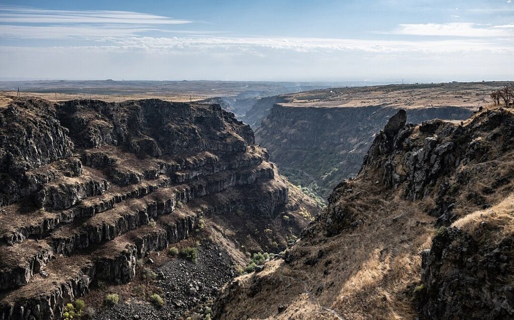
Aragatsotn’s geography is defined by its position between Yerevan and Mount Aragats, with elevations ranging from 950 meters in the lowlands to 4,090 meters at the mountain’s peak. The region is rich in natural water sources, with numerous cold springs emerging from its volcanic terrain. The Kasakh River, along with its tributaries—the Gegharot and Amberd—serves as the main waterway, while the Aparan Reservoir plays a crucial role in irrigation. The Mastara mudflow creek, notorious for its occasional damage to crops, also runs through the region.
In the high-altitude areas near Aragats’ summit lies Lake Kari, a picturesque alpine lake surrounded by lush meadows and rugged gorges. Some parts of the region are covered in oak forests, adding to its diverse natural beauty.
Must-See Landmarks in Aragatsotn region
Aragatsotn Marz is dotted with ancient churches, monasteries, and fortresses, each with its own story to tell. Some of the most notable historical and architectural sites include:
- Amberd Fortress (10th–13th centuries) – A medieval stronghold on the slopes of Mount Aragats.
- Byurakan Teher Monastery (13th century) – A lesser-known but historically significant monastery.
- St. John’s Church (10th century, Byurakan) – A beautifully preserved early Christian church.
- Artavazdik Church (7th–13th centuries, Byurakan) – A remarkable religious site.
- Tomb of Armenian Kings (4th century, Aghdzk) – A royal burial site from the early Christian period.
- St. Stepanos Church (7th century, Gosh) – An ancient church of significant cultural value.
- Khachkar of Gosh (1175) – An intricately carved Armenian cross-stone.
- Aruch Caravanserai (12th–14th centuries) – A historical resting place for travelers on trade routes.
- Aruch Church (7th century) – A stunning early medieval church.
- Saghmosavank Monastery (13th century) – A monastery perched above the deep Kasakh Gorge.
- Hovhannavank Monastery (5th–13th centuries) – A major spiritual center of medieval Armenia.
- Mankanots Church (7th century, Oshakan) – A significant early Christian church.
- Kasakh Basilica (5th century, Aparan) – One of Armenia’s oldest standing churches.
- Astvatskal Church (5th–13th centuries, Artavan) – An ancient place of worship.